Surf Forecast for Yung Shue Wan
We provide you with the latest data of sea water conditions for Yung Shue Wan for an accurate surf forecast. We take into consideration wave height, sea state and wind direction so you can have all the information about your destination before you reach the beach.
Yung Shue Wan sea conditions and wind forecast
What is the waves like today in Yung Shue Wan? Today the wave height in Yung Shue Wan does not exceed 1 meter (3 ft 3 in) and it is sea suitable for swimming. In the coming days the sea will remain calm. The table below provides detailed information about the sea conditions for the next 10 days by time of day. These data show wave height, wave direction and WMO sea state code (is a scale which measures the height of the waves). The values are for informational purposes only and should not be used for navigation.
Sea state, wave height and direction
23 February 2026
| 0-3 h | 3-6 h | 6-9 h | 9-12 h |
| 1' 7" | 1' 10" | 1' 9" | 1' 8" |
| 0.47 m | 0.55 m | 0.53 m | 0.5 m |
 E E |  E E |  E E |  E E |
| 2 | 3 | 3 | 2 |
| 12-15 h | 15-18 h | 18-21 h | 21-24 h |
| 1' 7" | 1' 7" | 1' 6" | 1' 5" |
| 0.48 m | 0.48 m | 0.45 m | 0.43 m |
 E E |  E E |  E E |  E E |
| 2 | 2 | 2 | 2 |
Time and date of surf forecast in charts and tables in GMT +0 format. You can choose a different time zone for yourself:
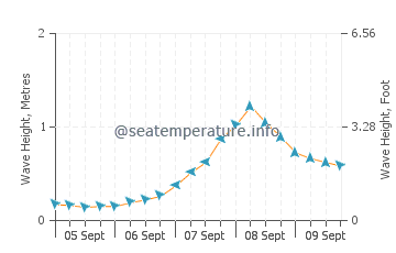
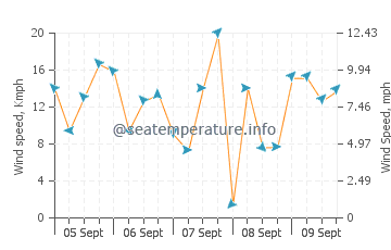
The sea state graph shows the height and direction of the wave in Yung Shue Wan for the next few days. The second shows the speed and direction of the wind.
You may also be interested in other sections of our site for Yung Shue Wan: Sea temperature, Sunrise and Sunset, Tides
State of the sea
0 - Calm Sea - Sea surface is calm with a mirror stillness. Wave height 0 metres (0 ft)
1 - Ripple Effect - Sea surface has a slight ripple and a slight breeze. Wave height 0 to 0.1 metres (0.00 to 0.33 ft)
2 - Smooth Sea - Sea surface is smooth but wavelets begin to form. Wave height 0.1 to 0.5 metres (3.9 in to 1 ft 7.7 in)
3 - Gentle Breeze - Sea surface broken with large wavelets. Wave height 0.5 to 1.25 metres (1 ft 8 in to 4 ft 1 in)
4 - Moderate Force - Sea surface wind picking up speed and small waves becoming longer. Wave height 1.25 to 2.5 metres (4 ft 1 in to 8 ft 2 in)
5 - Choppy Sea - Sea surface becoming rough and moderate waves crashing. Wave height 2.5 to 4 metres (8 ft 2 in to 13 ft 1 in)
6 - Rough Sea - Sea surface broken with large waves. Wave height 4 to 6 metres (13 to 20 ft)
7 - High - Moderate gale with strong winds. Wave height 6 to 9 metres (20 to 30 ft)
8 - Very high - high waves and strong winds. Wave height 9 to 14 metres (30 to 46 ft)
9 - Phenomenal - high waves impede visibility. Wave height over 14 metres (46 ft)
Yung Shue Wan surf forecast by month
In order for you to choose the most comfortable month for your vacation, we will provide a graph comparing the height of waves in Yung Shue Wan for the last 3 years. Click on a month to view


