Weather forecast in Vierville-sur-Mer
This data display current weather and forecast for the coming days in Vierville-sur-Mer. In addition to temperature, wind, humidity and pressure, we include data on the probability of precipitation so you can have all the information about your destination before your trip.
Vierville-sur-Mer current temperature and weather
| 28 February 2026 |
| Night | ||
7.9°C Feels like: 3.5°C | Patchy rain nearby | |
Wind: 33.5 Km/h (20.8 mph)  W WPressure: 1015 hPa (29.97 inHg) Humidity: 84% | Precip. prob.: 100% Visibility: 10 km (6 mi) UV index: 0 | |
| Morning | ||
7.5°C Feels like: 4.1°C | Patchy rain nearby | |
| Wind: 21.6 Km/h (13.4 mph) W Pressure: 1020 hPa (30.12 inHg) Humidity: 87% | Precip. prob.: 61% Visibility: 10 km (6 mi) UV index: 0.1 | |
| Day | ||
10.4°C Feels like: 7.8°C | Patchy rain nearby | |
| Wind: 20.5 Km/h (12.8 mph) W Pressure: 1023 hPa (30.21 inHg) Humidity: 68% | Precip. prob.: 82% Visibility: 10 km (6 mi) UV index: 1.3 | |
| Evening | ||
4.5°C Feels like: 2.7°C | Partly Cloudy | |
Wind: 7.6 Km/h (4.7 mph)  S SPressure: 1025 hPa (30.26 inHg) Humidity: 87% | Precip. prob.: 0% Visibility: 10 km (6 mi) UV index: 0 | |
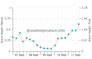
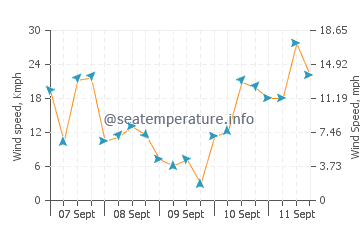
Marine weather forecast Vierville-sur-Mer
The graphs show wave heights and directions, as well as wind speed and direction in Vierville-sur-Mer for the coming days. Click on the sea state chart for more details
You may also be interested in other sections of our site for Vierville-sur-Mer: Sea temperature, Sunrise and Sunset, Tides
Vierville-sur-Mer weather by month
In order for you to be able to estimate what the weather is like in Vierville-sur-Mer throughout the year, we provide monthly data for the last few years. Select the month you are interested in.
