Weather forecast in Ver-sur-Mer
This data display current weather and forecast for the coming days in Ver-sur-Mer. In addition to temperature, wind, humidity and pressure, we include data on the probability of precipitation so you can have all the information about your destination before your trip.
Ver-sur-Mer current temperature and weather
| 11 March 2026 |
| Night | ||
8.6°C Feels like: 4.9°C | Patchy rain nearby | |
Wind: 28.4 Km/h (17.7 mph)  SW SWPressure: 1014 hPa (29.93 inHg) Humidity: 86% | Precip. prob.: 52% Visibility: 10 km (6 mi) UV index: 0 | |
| Morning | ||
9.7°C Feels like: 6.5°C | Patchy rain nearby | |
Wind: 25.6 Km/h (15.9 mph)  W WPressure: 1013 hPa (29.92 inHg) Humidity: 93% | Precip. prob.: 100% Visibility: 10 km (6 mi) UV index: 0 | |
| Day | ||
11°C Feels like: 8.3°C | Patchy rain nearby | |
Wind: 24.1 Km/h (15 mph)  NW NWPressure: 1017 hPa (30.04 inHg) Humidity: 63% | Precip. prob.: 66% Visibility: 10 km (6 mi) UV index: 1.6 | |
| Evening | ||
5.1°C Feels like: 2.2°C | Clear | |
| Wind: 13.3 Km/h (8.3 mph) W Pressure: 1022 hPa (30.19 inHg) Humidity: 92% | Precip. prob.: 0% Visibility: 10 km (6 mi) UV index: 0 | |
Want to know the water temperature and sea conditions in a location you're interested in without having to search for it every time? Install our app for Android or iOS and stay up-to-date.
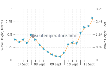
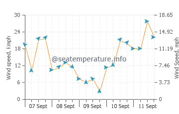
Marine weather forecast Ver-sur-Mer
The graphs show wave heights and directions, as well as wind speed and direction in Ver-sur-Mer for the coming days. Click on the sea state chart for more details
You may also be interested in other sections of our site for Ver-sur-Mer: Sea temperature, Sunrise and Sunset, Tides
Ver-sur-Mer weather by month
In order for you to be able to estimate what the weather is like in Ver-sur-Mer throughout the year, we provide monthly data for the last few years. Select the month you are interested in.
