Tides forecast for Ambergris Caye
This section provides data on the height and time of tides in Ambergris Caye for today and the coming days. The values are for informational purposes only and should not be used for navigation.
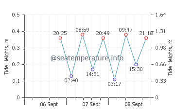
Tide Times Ambergris Caye
Data is given for the point with coordinates 17.5, -88.18, tide times are given for the 'America/Belize' time zone. The tidal heights below show the rise of sea level relative to the mean low tide (MLLW). These data are astronomical tides and may vary due to the effects of storms, wind, atmospheric pressure and cannot be used for navigation.
23 February 2026
| High tide ⬆ 3:18 AM (03:18), Height: 0.85 ft (0.26 m) |
| Low tide ⬇ 8:55 AM (08:55), Height: 0.59 ft (0.18 m) |
| High tide ⬆ 2:25 PM (14:25), Height: 0.79 ft (0.24 m) |
| Low tide ⬇ 9:45 PM (21:45), Height: 0.16 ft (0.05 m) |
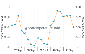
Ambergris Caye tide and wave chart
The graphs show changes in the height of the high and low tides, as well wave heights and directions in Ambergris Caye for the coming days. Click on the sea state chart for more details.
You may also be interested in other sections of our site for Ambergris Caye: Sea temperature, Sunrise and Sunset, Weather forecast
